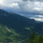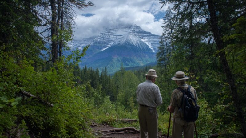
Glacier National Park offers over 700 miles of hiking trails (National Park Service, 2024), but not all are suitable for older adults who want scenic beauty without steep climbs or dangerous footing.
The best trails for seniors are those that combine manageable distances, gentle elevation gains, reliable footing, accessible trailheads, and high scenic rewards. Based on National Park Service accessibility data, visitor reports, and AllTrails difficulty ratings, the most senior-friendly options typically fall under 5 miles round trip with elevation gains under 500 feet.
This post covers 10 trails that meet these criteria, each offering a memorable experience, from waterfalls to alpine lakes, without requiring strenuous exertion.
According to the NPS Visitor Use Statistics Program, nearly 15% of Glacier National Park’s annual visitors are aged 60 or older, making senior-friendly hikes an important part of the park’s trail planning. The following list is backed by official trail specs, condition reports, and hiker reviews,n ot just generic travel advice.
1. Trail of the Cedars
View this post on Instagram
The Trail of the Cedars is one of the most accessible and popular hikes in Glacier National Park, located along Going-to-the-Sun Road near the Avalanche Creek area. This 1-mile loop is mostly boardwalk and paved path, making it suitable for wheelchairs, mobility aids, and visitors with limited stamina.
The trail winds through a lush grove of western red cedars, some over 500 years old and reaching heights of more than 100 feet. Interpretive signs provide educational context about the ecosystem. About halfway through, the trail passes Avalanche Gorge, where turquoise water carves through colorful rock.
Because the elevation gain is negligible, this trail can be enjoyed at a slow pace with frequent rest stops. Parking fills quickly during summer, so arriving early is recommended.
Trail of the Cedars – Quick Facts
| Attribute | Details |
| Trailhead Location | Avalanche Creek area, Going-to-the-Sun Road |
| Distance (Loop) | 1 mile |
| Elevation Gain | ~50 ft |
| Trail Surface | Paved and boardwalk |
| Difficulty | Easy |
| Amenities | Restrooms at the trailhead, benches along the route |
| Highlights | Old-growth cedar forest, Avalanche Gorge, fully accessible |
2. Running Eagle Falls (Trick Falls)
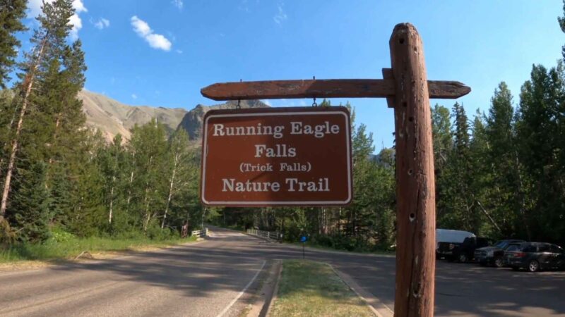
Located in the Two Medicine area, the Running Eagle Falls Trail is one of the shortest and easiest in Glacier National Park. At 0.6 miles round trip, the path is mostly flat and surfaced with well-maintained gravel, suitable for casual walkers.
The waterfall is unique because it changes appearance with the seasons: in spring and early summer, water spills over the top of the rock face; by late summer, it flows through an opening in the cliff, giving the illusion of emerging from nowhere, earning it the nickname “Trick Falls.”
This area also has interpretive panels explaining the cultural significance of the falls to the Blackfeet Nation.
| Attribute | Details |
| Trailhead Location | Two Medicine area, near campground |
| Distance (RT) | 0.6 miles |
| Elevation Gain | ~25 ft |
| Trail Surface | Gravel |
| Difficulty | Easy |
| Amenities | Rest benches, parking, restrooms nearby |
| Highlights | Seasonal dual-waterfall effect, cultural history |
3. St. Mary Falls (Optional Virginia Falls Extension)
View this post on Instagram
The St. Mary Falls Trail begins from the Going-to-the-Sun Road shuttle stop and heads downhill toward the turquoise waters of the St. Mary River. The main route to St. Mary Falls is 1.6 miles one-way, with a modest 260-foot descent.
Those wanting a bigger challenge can continue an additional 0.8 miles to Virginia Falls, which is taller and more dramatic.
Benches near St. Mary Falls allow for comfortable resting while enjoying the view. The trail is well-trodden dirt, and though it descends first, hikers should remember the return trip is uphill. Seniors with good stamina and trekking poles will find this hike very rewarding.
| Attribute | Details |
| Trailhead Location | Going-to-the-Sun Road, St. Mary Falls shuttle stop |
| Distance (RT) | 3.2 mi (St. Mary) / 5.4 mi (Virginia) |
| Elevation Gain | 260 ft to St. Mary; ~450 ft total to Virginia |
| Trail Surface | Dirt and gravel |
| Difficulty | Easy–Moderate |
| Amenities | Shuttle access, benches at St. Mary Falls |
| Highlights | Two major waterfalls, a lush forest, and birdlife |
4. Avalanche Lake via Trail of the Cedars
For seniors looking for a moderate but scenic outing, the 4.6-mile round trip to Avalanche Lake is an excellent choice. Beginning on the Trail of the Cedars boardwalk, it follows Avalanche Creek through old-growth forest before gradually climbing to the lake. The total elevation gain is about 730 feet, so pacing is key.
At the lake, towering cliffs surround the water, with multiple waterfalls cascading down in the distance. There are several shoreline spots where hikers can sit and take in the view. Because of its popularity, the trail can be busy, so starting early helps avoid crowds.
Avalanche Lake – Quick Facts
| Attribute | Details |
| Trailhead Location | Avalanche Creek, Going-to-the-Sun Road |
| Distance (RT) | 4.6 miles |
| Elevation Gain | ~730 ft |
| Trail Surface | Dirt |
| Difficulty | Moderate |
| Amenities | Restrooms at the trailhead, benches at the lake |
| Highlights | Alpine lake, waterfalls, shaded forest |
5. Hidden Lake Overlook
This trail starts at the Logan Pass Visitor Center and is a 2.8-mile round trip to one of the most photographed viewpoints in the park. The route is partially boardwalk and partially dirt, climbing about 540 feet to the overlook. Wildlife sightings are common, including mountain goats, marmots, and sometimes bighorn sheep.
Because the trail is at over 6,600 feet, the combination of altitude and exposure means seniors should pace themselves and take precautions. Carrying essentials like water, trekking poles, and Life Assure bracelets can add a layer of safety, especially since cell coverage in the area is unreliable.
Snow can linger on this trail well into July, so checking with rangers before heading out is advised. The elevation can make the climb feel more challenging, so frequent rest stops are recommended.
| Attribute | Details |
| Trailhead Location | Logan Pass Visitor Center |
| Distance (RT) | 2.8 miles |
| Elevation Gain | ~540 ft |
| Trail Surface | Boardwalk and dirt |
| Difficulty | Moderate |
| Amenities | Visitor center restrooms, benches along boardwalk |
| Highlights | Alpine lake views, wildlife, wildflowers |
6. Redrock Falls
@willowywhisper The hike to Red Rock Falls went unspoiled by rain the whole time. #waterfall #glaciernationalpark ##montana #nature #hike #vibes #outdoor #mountains #naturehike #rock #girlstrip #vacation #2024 ♬ Pieces (Solo Piano Version) – Danilo Stankovic
The Redrock Falls Trail in the Many Glacier area is a 3.6-mile round trip with only about 100 feet of elevation gain. The path is wide and mostly flat, winding through meadows and forest. In late summer, huckleberries line parts of the route, and the area is prime for moose sightings.
The falls themselves are multi-tiered cascades flowing into a pool, with large rocks that serve as natural benches. The trail starts from the Swiftcurrent Pass trailhead and can be busy during peak wildlife activity times.
| Attribute | Details |
| Trailhead Location | Swiftcurrent Pass Trailhead, Many Glacier |
| Distance (RT) | 3.6 miles |
| Elevation Gain | ~100 ft |
| Trail Surface | Dirt |
| Difficulty | Easy |
| Amenities | Parking, restrooms at the campground nearby |
| Highlights | Moose habitat, berry patches, cascading falls |
7. Rocky Point Nature Trail
This 1.9-mile loop near Lake McDonald provides some of the park’s best low-effort lake views. With about 150 feet of elevation gain, the trail gently climbs to an overlook before dropping back to the lakeshore.
The area is less crowded than the main Lake McDonald Lodge area, making it a peaceful option. Wildlife like bald eagles and deer are often spotted along the route. Afternoon light creates excellent photo opportunities across the lake.
| Attribute | Details |
| Trailhead Location | Near Fish Creek Campground, Lake McDonald |
| Distance (RT) | 1.9 miles |
| Elevation Gain | ~150 ft |
| Trail Surface | Dirt |
| Difficulty | Easy |
| Amenities | Parking nearby, no restrooms on the trail |
| Highlights | Lake views, birdwatching, fewer crowds |
8. Forest and Fire Nature Trail
The Forest and Fire Nature Trail is a short 1.1-mile loop with interpretive signs explaining the 2003 Roberts Fire and how the forest is regenerating. With minimal elevation gain, it’s suitable for almost all fitness levels.
In summer, wildflowers cover the open hillsides, and the trail’s location near the St. Mary Visitor Center makes it an easy add-on to a day’s visit. Because the trail is open and exposed, wearing sun protection is recommended.
| Attribute | Details |
| Trailhead Location | Near St. Mary Visitor Center |
| Distance (RT) | 1.1 miles |
| Elevation Gain | ~75 ft |
| Trail Surface | Dirt |
| Difficulty | Easy |
| Amenities | Visitor center facilities nearby |
| Highlights | Post-fire regrowth, wildflowers, and educational signage |
9. Kootenai Lakes Trail
The Kootenai Lakes Trail is a 5.5-mile out-and-back with minimal elevation change, located in the remote northwest section of the park. The trail passes two small lakes and wetlands, which are ideal for spotting moose and waterfowl.
Because it’s in a quieter section of the park, the trail sees fewer visitors, offering a more secluded experience. The route can be muddy in the early season, so waterproof footwear is recommended.
| Attribute | Details |
| Trailhead Location | Goat Haunt area (seasonal access) |
| Distance (RT) | 5.5 miles |
| Elevation Gain | ~150 ft |
| Trail Surface | Dirt, occasional boardwalk |
| Difficulty | Easy–Moderate (due to distance) |
| Amenities | Limited; no restrooms on the trail |
| Highlights | Moose viewing, birdwatching, peaceful setting |
10. Upper Two Medicine Lake Loop (Boat Option)
@anderson.252 Twin Falls and Upper Two Medicine Lake We took the Sinopah Boat Tour across the lake. We hiked a total of 4.6 miles round trip from the boat and back to Twin Falls and Upper Two Medicine Lake. We took the 10am over and got back on the 1:15 pm back. Great views of the Two Medicine area!! #glaciernationalpark #twomedicine #twomedicinelake #eastglaciernationalpark #eastglacier #twinfalls #glacier #montana ♬ Sweet Heat Lightning – Gregory Alan Isakov
The Upper Two Medicine Lake Trail is a 5-mile loop that can be shortened to just 2 miles total by using the Two Medicine Lake boat shuttle. This flexibility makes it an excellent senior-friendly hike.
The trail offers constant lake and mountain views, and the boat ride itself is a scenic highlight. Benches and picnic spots are available along the shore, making it perfect for a relaxed day outing.
| Attribute | Details |
| Trailhead Location | Two Medicine boat dock |
| Distance (RT) | 5 miles (2 with boat) |
| Elevation Gain | ~150 ft |
| Trail Surface | Dirt |
| Difficulty | Easy |
| Amenities | Boat shuttle, restrooms at the dock |
| Highlights | Lake views, flexible route length, wildlife |
Bottom Line
Glacier National Park is often thought of as a rugged, backcountry destination, but these 10 trails prove that you do not have to tackle grueling climbs to experience its world-class scenery.
Whether it is the short and shaded Trail of the Cedars, the wildlife-rich Redrock Falls, or the iconic Hidden Lake Overlook, each hike offers seniors a chance to connect with the park’s landscapes at a comfortable pace. Other than hiking, there are many other options you can do with friends and family.
The key is knowing your limits, starting early to avoid crowds and heat, and choosing routes that balance accessibility with reward. With distances ranging from less than a mile to a manageable five, and most elevation gains under 500 feet, these trails allow older visitors to enjoy Glacier’s waterfalls, alpine lakes, and forests without overexertion.
By pairing good preparation, like bringing water, trekking poles, and checking trail conditions, with these senior-friendly routes, it is entirely possible to leave the park with lasting memories, beautiful photos, and the satisfaction of having explored one of America’s most breathtaking protected areas on foot.
I’m Annabel, and traveling has always been my passion. My idea of fun? A lot of biking and hiking. From the Himalayas to the local hills, if there’s a path (or not), I’ve probably been there or it’s on my list.